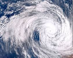
The Zambia Meteorological Department (ZMD) has announced that it is closely monitoring the progression of Tropical Cyclone Gezani that made landfall over the east coast of Madagascar yesterday, Tuesday, 10thof February 2026. Giving an update on Cyclone Gezani, ZMD disclosed that the cyclone was Intense at the time it made landfall over Madagascar with maximum average wind speeds of 148 km/h and a central minimum sea-level pressure estimated around 975hpa. The media reports that the Department describes the current status of the cyclone as severe, with sustained winds of 130Km/h and a pressure level 985 Hpa.
The storm is projected to be in the Mozambique Channel by tomorrow, Thursday, 12th February 2026. ZMD revealed that its interaction with the Intertropical Convergence Zone (ITCZ) is expected to further enhance rainfall activities across Zambia. The impact of the interaction with the ITCZ includes widespread rainfall with periodical Heavy falls.
It is anticipated that significant rainfall amounts may lead to flooding, especially in low-lying areas and along river banks. Other effects are enhanced soil moisture, as a result of waterlogging and flooding, increased thunderstorms and lightning activities may occur, posing risks of lightning strikes. “Strong Winds: Occurrence of gusty winds could cause damage to infrastructure and vegetation,” stated ZMD.
Read Full Article on Lusaka Times
[paywall]
Meanwhile, ZMD has warned the public to avoid low-lying areas due to expected flooding and also to desist from crossing flooded points, roads and bridges. The Department has further cautioned the public to avoid outdoor activities during thunderstorms and seek shelter indoors. This is contained in a media update on Cyclone Gezani issued to ZANIS by the Zambia Meteorological Department in Lusaka.
[/paywall]
All Zim News – Bringing you the latest news and updates.