A park in Patchogue is inundated with water from the storm surge of Hurricane Irene in 2011.Credit: Thomas A FerraraByNicholas Spanglernicholas.spangler@newsday.comspanglernewsdayUpdated May 22, 2025ShareA decadeslong stretch of high hurricane activity in the Atlantic will likely continue this season, with up to 10 forecast, according to a National Oceanic and Atmospheric Administration outlook issued Thursday.Typically, hurricane season averages 14 named storms including seven hurricanes, three of them major, defined as Category 3 or stronger, with winds of 111 mph or higher.NOAA forecast13 to 19 total named storms, including six to 10 hurricanes and three to five major hurricanes.The outlook does not predict how many storms will make landfall or what areas they might affect The outlook for hurricane season, which lasts from June 1 to Nov 30, predicts a 10% chance of a below-normal season in 2025, a 30% chance of a near-normal season and a 60% chance of something more.”Everything’s in place for an above-average season,” National Weather Service director Ken Graham told reporters in a briefing.WHAT NEWSDAY FOUNDA decadeslong stretch of high hurricane activity in the Atlanticwill likely continue this season, with up to 10 forecast, according to an NOAA outlook.The NOAA forecast 13 to 19 total named storms,including6-10 hurricanes and 3-5 major hurricanes.The outlook for hurricane season, which lastsfrom June 1 to Nov
30, predicts a 10% chance of a below-normal season in 2025, a 30% chance of a near-normal season and a 60% chance of something more.Stronger storm factorsFactors the weather service cited include warmer-than-average ocean temperatures, which provide more energy to fuel storm development, along with forecasts for weak wind shear Strong wind shear would disrupt tropical storms before they develop into hurricanes Meteorologists also said there was potential for higher activity from the West African monsoon, where many Atlantic hurricanes develop.Extreme storm events are becoming a greater threat to New York, according to the state Department of Environmental Conservation, in part because storm surge, one of the most dangerous impacts of rotating storms, is worsened by rising sea levels.In 2011, Hurricane Irene and Tropical Storm Lee hit the East Coast back to back, bringing damaging winds, extreme precipitation and significant flooding In 2012,Superstorm Sandybrought heavy rains, strong winds and record storm surge, causing $60 billion in “catastrophic damage” to Long Island, New York City and New Jersey, according to the DEC
In August 2020,Tropical Storm Isaiastook out power to more than 650,000 of LIPA’s 1.2 million customers.Last August, a series of storms caused $41 million in flood damage in Suffolk County, mostly on the North Shore.Hurricane historySince 1934, Long Island has been battered by more than 44 tropical storms and hurricanes The deadliest weren’t always the strongest: the1938 Long Island Express, which made landfall near Bellport as a Category 3 hurricane, with maximum sustained winds of about 120 mph, killed about 60 people, injured hundreds more and destroyed thousands of homes and farms.In a statement Thursday, Nassau County Executive Bruce Blakeman said that “each and every year we prepare for the worst, and hope for the best We monitor the weather closely and train frequently to make sure that all of our assets are available should there be a hurricane or any other emergency.”Suffolk County Executive Edward P Romaine did not respond to a request for comment.Hyper-active storm seasonsAccording to the NOAA, this year’s North Atlantic hurricane season could be theninth out of the last 11with above-average activity
Since 1995, 21 of 30 seasons have had above-normal activity and half of those have been hyper-active, a category NOAA reserves for years where the measure of accumulated cyclone energy over a season is especially large.A hotter planet does not appear to be yielding more storms or even stronger ones, Graham said in response to a reporter’s question about the impact of climate change But, because warmer air holds more moisture, meteorologists are seeing heavier rainfall, he said.”You go to some of these communities [and hear] ‘I’ve lived here my whole life, I’ve never seen rainfall rates like that,’ ” he said.The weather service’s outlook joined several already released, including one from Colorado State University predicting 17 named storms, nine hurricanes and four major hurricanes The university’s model predicted a 51% chance that a major hurricane will make landfall on the East Coast, higher than the 43% average chance for the period from 1880 to 2020.AfterTrump administration job cutsthis spring, nearly half the National Weather Service forecast offices had 20% vacancy rates, a level experts said met the threshold for critical understaffing.Laura Grimm, NOAA chief of staff, said the hurricane center, which coordinates warnings and forecasts, was fully staffed.Graham said hurricane prediction would not be affected.”The models are as good as they’ve ever been,” he said
But Graham added a warning: “It only takes one So we got to be prepared right now.”With APByNicholas Spanglernicholas.spangler@newsday.comspanglernewsdayNicholas Spangler is a general assignment reporter and has worked at Newsday since 2010.More on this topicOnly in NewsdayWhat warmer temperatures mean for hurricanes and LIOnly in NewsdayMany LI properties get flooded more than oncenewsday-tv-logoStreaming NowHer 25-day disappearance grabbed national attention after she was found on a yacht What her story reveals about LI’s hidden world of drugs and sex trafficking Newsday reporters Shari Einhorn, Grant Parpan and Sandra Peddie have the story.’She’s broken
She’s so broken’Her 25-day disappearance grabbed national attention after she was found on a yacht What her story reveals about LI’s hidden world of drugs and sex trafficking Newsday reporters Shari Einhorn, Grant Parpan and Sandra Peddie have the story.Get more on these and other NewsdayTV stories
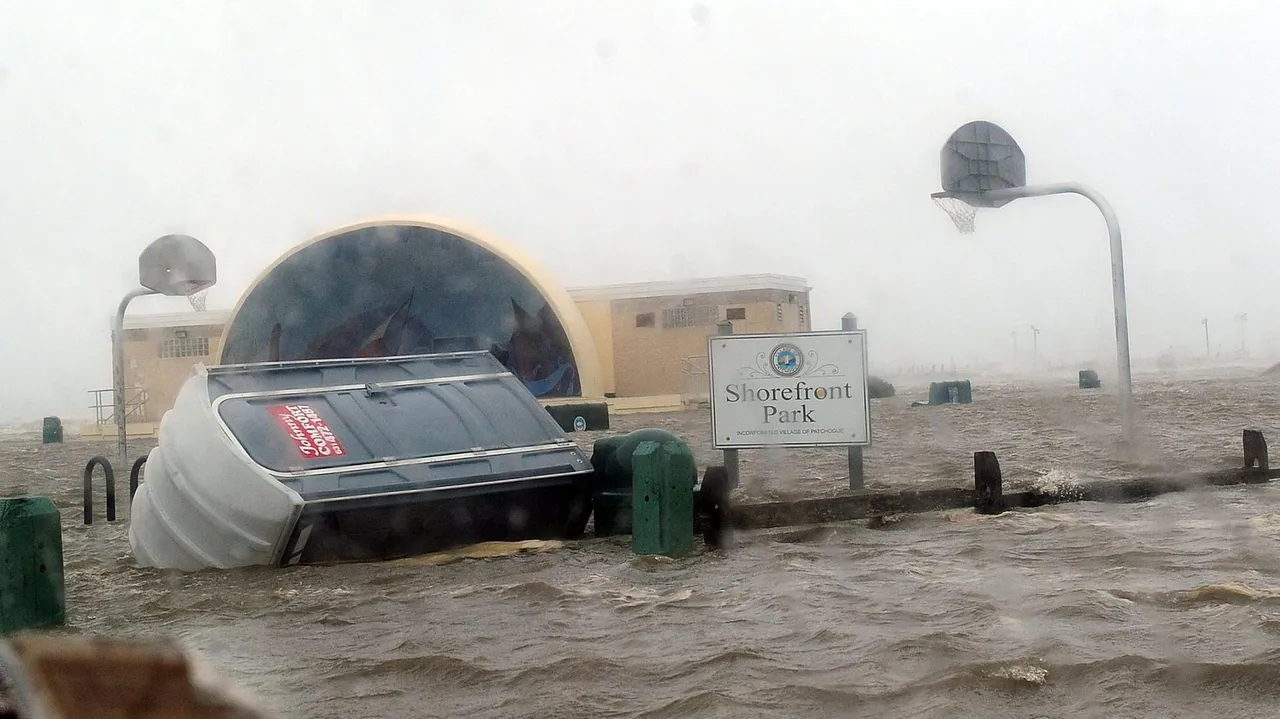
A park in Patchogue is inundated with water from the storm surge of Hurricane Irene in 2011.Credit: Thomas A Ferrara
ByNicholas Spanglernicholas.spangler@newsday.comspanglernewsdayUpdated May 22, 2025
A decadeslong stretch of high hurricane activity in the Atlantic will likely continue this season, with up to 10 forecast, according to a National Oceanic and Atmospheric Administration outlook issued Thursday.Typically, hurricane season averages 14 named storms including seven hurricanes, three of them major, defined as Category 3 or stronger, with winds of 111 mph or higher.NOAA forecast13 to 19 total named storms, including six to 10 hurricanes and three to five major hurricanes.The outlook does not predict how many storms will make landfall or what areas they might affect
The outlook for hurricane season, which lasts from June 1 to Nov 30, predicts a 10% chance of a below-normal season in 2025, a 30% chance of a near-normal season and a 60% chance of something more.”Everything’s in place for an above-average season,” National Weather Service director Ken Graham told reporters in a briefing.WHAT NEWSDAY FOUNDA decadeslong stretch of high hurricane activity in the Atlanticwill likely continue this season, with up to 10 forecast, according to an NOAA outlook.The NOAA forecast 13 to 19 total named storms,including6-10 hurricanes and 3-5 major hurricanes.The outlook for hurricane season, which lastsfrom June 1 to Nov 30, predicts a 10% chance of a below-normal season in 2025, a 30% chance of a near-normal season and a 60% chance of something more.Stronger storm factorsFactors the weather service cited include warmer-than-average ocean temperatures, which provide more energy to fuel storm development, along with forecasts for weak wind shear Strong wind shear would disrupt tropical storms before they develop into hurricanes
Meteorologists also said there was potential for higher activity from the West African monsoon, where many Atlantic hurricanes develop.Extreme storm events are becoming a greater threat to New York, according to the state Department of Environmental Conservation, in part because storm surge, one of the most dangerous impacts of rotating storms, is worsened by rising sea levels.In 2011, Hurricane Irene and Tropical Storm Lee hit the East Coast back to back, bringing damaging winds, extreme precipitation and significant flooding In 2012,Superstorm Sandybrought heavy rains, strong winds and record storm surge, causing $60 billion in “catastrophic damage” to Long Island, New York City and New Jersey, according to the DEC In August 2020,Tropical Storm Isaiastook out power to more than 650,000 of LIPA’s 1.2 million customers.Last August, a series of storms caused $41 million in flood damage in Suffolk County, mostly on the North Shore.Hurricane historySince 1934, Long Island has been battered by more than 44 tropical storms and hurricanes The deadliest weren’t always the strongest: the1938 Long Island Express, which made landfall near Bellport as a Category 3 hurricane, with maximum sustained winds of about 120 mph, killed about 60 people, injured hundreds more and destroyed thousands of homes and farms.In a statement Thursday, Nassau County Executive Bruce Blakeman said that “each and every year we prepare for the worst, and hope for the best
We monitor the weather closely and train frequently to make sure that all of our assets are available should there be a hurricane or any other emergency.”Suffolk County Executive Edward P Romaine did not respond to a request for comment.Hyper-active storm seasonsAccording to the NOAA, this year’s North Atlantic hurricane season could be theninth out of the last 11with above-average activity Since 1995, 21 of 30 seasons have had above-normal activity and half of those have been hyper-active, a category NOAA reserves for years where the measure of accumulated cyclone energy over a season is especially large.A hotter planet does not appear to be yielding more storms or even stronger ones, Graham said in response to a reporter’s question about the impact of climate change But, because warmer air holds more moisture, meteorologists are seeing heavier rainfall, he said.”You go to some of these communities [and hear]
‘I’ve lived here my whole life, I’ve never seen rainfall rates like that,’ ” he said.The weather service’s outlook joined several already released, including one from Colorado State University predicting 17 named storms, nine hurricanes and four major hurricanes The university’s model predicted a 51% chance that a major hurricane will make landfall on the East Coast, higher than the 43% average chance for the period from 1880 to 2020.AfterTrump administration job cutsthis spring, nearly half the National Weather Service forecast offices had 20% vacancy rates, a level experts said met the threshold for critical understaffing.Laura Grimm, NOAA chief of staff, said the hurricane center, which coordinates warnings and forecasts, was fully staffed.Graham said hurricane prediction would not be affected.”The models are as good as they’ve ever been,” he said But Graham added a warning: “It only takes one So we got to be prepared right now.”With APByNicholas Spanglernicholas.spangler@newsday.comspanglernewsdayNicholas Spangler is a general assignment reporter and has worked at Newsday since 2010
A decadeslong stretch of high hurricane activity in the Atlantic will likely continue this season, with up to 10 forecast, according to a National Oceanic and Atmospheric Administration outlook issued Thursday.Typically, hurricane season averages 14 named storms including seven hurricanes, three of them major, defined as Category 3 or stronger, with winds of 111 mph or higher.NOAA forecast13 to 19 total named storms, including six to 10 hurricanes and three to five major hurricanes.The outlook does not predict how many storms will make landfall or what areas they might affect The outlook for hurricane season, which lasts from June 1 to Nov 30, predicts a 10% chance of a below-normal season in 2025, a 30% chance of a near-normal season and a 60% chance of something more.”Everything’s in place for an above-average season,” National Weather Service director Ken Graham told reporters in a briefing.WHAT NEWSDAY FOUNDA decadeslong stretch of high hurricane activity in the Atlanticwill likely continue this season, with up to 10 forecast, according to an NOAA outlook.The NOAA forecast 13 to 19 total named storms,including6-10 hurricanes and 3-5 major hurricanes.The outlook for hurricane season, which lastsfrom June 1 to Nov 30, predicts a 10% chance of a below-normal season in 2025, a 30% chance of a near-normal season and a 60% chance of something more.Stronger storm factorsFactors the weather service cited include warmer-than-average ocean temperatures, which provide more energy to fuel storm development, along with forecasts for weak wind shear
Strong wind shear would disrupt tropical storms before they develop into hurricanes Meteorologists also said there was potential for higher activity from the West African monsoon, where many Atlantic hurricanes develop.Extreme storm events are becoming a greater threat to New York, according to the state Department of Environmental Conservation, in part because storm surge, one of the most dangerous impacts of rotating storms, is worsened by rising sea levels.In 2011, Hurricane Irene and Tropical Storm Lee hit the East Coast back to back, bringing damaging winds, extreme precipitation and significant flooding In 2012,Superstorm Sandybrought heavy rains, strong winds and record storm surge, causing $60 billion in “catastrophic damage” to Long Island, New York City and New Jersey, according to the DEC In August 2020,Tropical Storm Isaiastook out power to more than 650,000 of LIPA’s 1.2 million customers.Last August, a series of storms caused $41 million in flood damage in Suffolk County, mostly on the North Shore.Hurricane historySince 1934, Long Island has been battered by more than 44 tropical storms and hurricanes
The deadliest weren’t always the strongest: the1938 Long Island Express, which made landfall near Bellport as a Category 3 hurricane, with maximum sustained winds of about 120 mph, killed about 60 people, injured hundreds more and destroyed thousands of homes and farms.In a statement Thursday, Nassau County Executive Bruce Blakeman said that “each and every year we prepare for the worst, and hope for the best We monitor the weather closely and train frequently to make sure that all of our assets are available should there be a hurricane or any other emergency.”Suffolk County Executive Edward P Romaine did not respond to a request for comment.Hyper-active storm seasonsAccording to the NOAA, this year’s North Atlantic hurricane season could be theninth out of the last 11with above-average activity Since 1995, 21 of 30 seasons have had above-normal activity and half of those have been hyper-active, a category NOAA reserves for years where the measure of accumulated cyclone energy over a season is especially large.A hotter planet does not appear to be yielding more storms or even stronger ones, Graham said in response to a reporter’s question about the impact of climate change
But, because warmer air holds more moisture, meteorologists are seeing heavier rainfall, he said.”You go to some of these communities [and hear] ‘I’ve lived here my whole life, I’ve never seen rainfall rates like that,’ ” he said.The weather service’s outlook joined several already released, including one from Colorado State University predicting 17 named storms, nine hurricanes and four major hurricanes The university’s model predicted a 51% chance that a major hurricane will make landfall on the East Coast, higher than the 43% average chance for the period from 1880 to 2020.AfterTrump administration job cutsthis spring, nearly half the National Weather Service forecast offices had 20% vacancy rates, a level experts said met the threshold for critical understaffing.Laura Grimm, NOAA chief of staff, said the hurricane center, which coordinates warnings and forecasts, was fully staffed.Graham said hurricane prediction would not be affected.”The models are as good as they’ve ever been,” he said But Graham added a warning: “It only takes one
So we got to be prepared right now.”With APByNicholas Spanglernicholas.spangler@newsday.comspanglernewsdayNicholas Spangler is a general assignment reporter and has worked at Newsday since 2010 A decadeslong stretch of high hurricane activity in the Atlantic will likely continue this season, with up to 10 forecast, according to a National Oceanic and Atmospheric Administration outlook issued Thursday Typically, hurricane season averages 14 named storms including seven hurricanes, three of them major, defined as Category 3 or stronger, with winds of 111 mph or higher.NOAA forecast13 to 19 total named storms, including six to 10 hurricanes and three to five major hurricanes The outlook does not predict how many storms will make landfall or what areas they might affect
The outlook for hurricane season, which lasts from June 1 to Nov 30, predicts a 10% chance of a below-normal season in 2025, a 30% chance of a near-normal season and a 60% chance of something more “Everything’s in place for an above-average season,” National Weather Service director Ken Graham told reporters in a briefing WHAT NEWSDAY FOUNDA decadeslong stretch of high hurricane activity in the Atlanticwill likely continue this season, with up to 10 forecast, according to an NOAA outlook.The NOAA forecast 13 to 19 total named storms,including6-10 hurricanes and 3-5 major hurricanes.The outlook for hurricane season, which lastsfrom June 1 to Nov
30, predicts a 10% chance of a below-normal season in 2025, a 30% chance of a near-normal season and a 60% chance of something more Factors the weather service cited include warmer-than-average ocean temperatures, which provide more energy to fuel storm development, along with forecasts for weak wind shear Strong wind shear would disrupt tropical storms before they develop into hurricanes Meteorologists also said there was potential for higher activity from the West African monsoon, where many Atlantic hurricanes develop
Extreme storm events are becoming a greater threat to New York, according to the state Department of Environmental Conservation, in part because storm surge, one of the most dangerous impacts of rotating storms, is worsened by rising sea levels In 2011, Hurricane Irene and Tropical Storm Lee hit the East Coast back to back, bringing damaging winds, extreme precipitation and significant flooding In 2012,Superstorm Sandybrought heavy rains, strong winds and record storm surge, causing $60 billion in “catastrophic damage” to Long Island, New York City and New Jersey, according to the DEC In August 2020,Tropical Storm Isaiastook out power to more than 650,000 of LIPA’s 1.2 million customers.Last August, a series of storms caused $41 million in flood damage in Suffolk County, mostly on the North Shore
Since 1934, Long Island has been battered by more than 44 tropical storms and hurricanes The deadliest weren’t always the strongest: the1938 Long Island Express, which made landfall near Bellport as a Category 3 hurricane, with maximum sustained winds of about 120 mph, killed about 60 people, injured hundreds more and destroyed thousands of homes and farms In a statement Thursday, Nassau County Executive Bruce Blakeman said that “each and every year we prepare for the worst, and hope for the best We monitor the weather closely and train frequently to make sure that all of our assets are available should there be a hurricane or any other emergency.”
Source: NewsDay.com
All Zim News
All Zim News is a central hub for all things Zimbabwean, curating news from across the country so no story is missed
Alongside aggregation, our team of nationwide reporters provides real-time, on-the-ground coverage Stay informed and connected — reach us at admin@allzimnews.com.
Source: Newsday_Com